Overview
|
Indonesia is the most volcanically active country on Earth, boasting 145 known Holocene volcanoes (Gertisser et al., 2011). With nearly 80 recorded eruptions since the mid-1500s, Mount Merapi, or, Gunung Merapi (literal translation "Mountain of Fire": http://en.wikipedia.org/wiki/Mount_Merapi) is arguably the most dangerous of all of Indonesia's volcanoes (Voight et al., 2000). It is part of the Sunda arc, a chain of volcanoes resulting from the northward subduction (6.5cm/yr: Zimmer and Erzinger et al. 2003) of the Indo-Australian Plate beneath the Eurasian Plate. Mt Merapi stands approximately 2,930 m (9,613 ft) above sea-level and forms a "classic" stratovolcano morphology when view from the west.
|
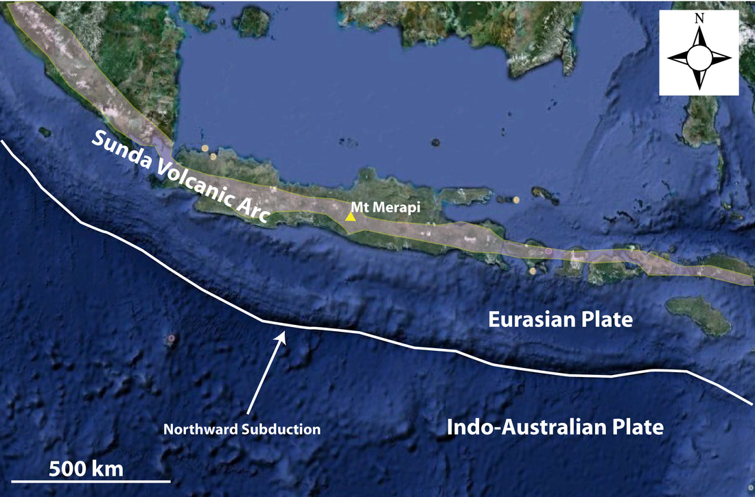
Figure 1: Tectonic setting of East Java in Indonesia showing the location of Mt Merapi in the Sunda Volcanic Arc. Image from Google Earth.
On clear days, white fumaroles are often seen extending up from the volcano's peak, however, this activity is benign compared to the continually growing threat on the summit. A viscous lava dome of basaltic andesite composition has been a permanent feature on the steep slopes of Merapi throughout the 20th and now 21st century. This dome is in a near-continuous state of growth. Every few years this growth is abruptly interrupted, and the dome collapses to generate block-and-ash flows traveling at velocities of more than 100km/h (Gertisser et al. 2011). Eruptions like these are so common at Merpai that the term "Merapi-type"
nuées ardentes has been adopted by many authors to describe these flows (Voight et al., 2000).
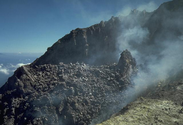
Figure 2: View of the lava at the top of Mt Merapi (image reference 2).
A growing population amongst a looming threat
Mt Merpai is located on the island of Java, which is the most densely populated island on Earth. Despite a century of near-continuous eruptions, the local population continues to increase. Today, more than 3 million people live within 40km of Merapi. The city of Yogyakarta, with a population of ~390,000, lies 28km from the summit. The Sleman regency, which sits 0-40km from the summit and has a population of 0.9 million, lies in the path of Merapi's frequent lahars and pyroclastic flows.
Although the threat of pyroclastic surges is ever present at Merapi, highly active volcanoes like these can also be considered "givers of life". For centuries Mt Merapi has provided a continuous flux of fresh, fertile soils and building materials for the local inhabitants. Fertile lands allow for surplus food, which in turn cater for the growth of specialists in arts and crafts, bureaucrats, and other workers that once built Java's ancient temples (e.g. Hindu temple complex at Prambanan) and developed a rich cultural history. By comparison, some of Indonesia's larger, yet volcanically inactive, islands have produced cultures that were dependent on hunting and gathering, with only small pockets of settled agriculture (internet resource 1).
Although the threat of pyroclastic surges is ever present at Merapi, highly active volcanoes like these can also be considered "givers of life". For centuries Mt Merapi has provided a continuous flux of fresh, fertile soils and building materials for the local inhabitants. Fertile lands allow for surplus food, which in turn cater for the growth of specialists in arts and crafts, bureaucrats, and other workers that once built Java's ancient temples (e.g. Hindu temple complex at Prambanan) and developed a rich cultural history. By comparison, some of Indonesia's larger, yet volcanically inactive, islands have produced cultures that were dependent on hunting and gathering, with only small pockets of settled agriculture (internet resource 1).
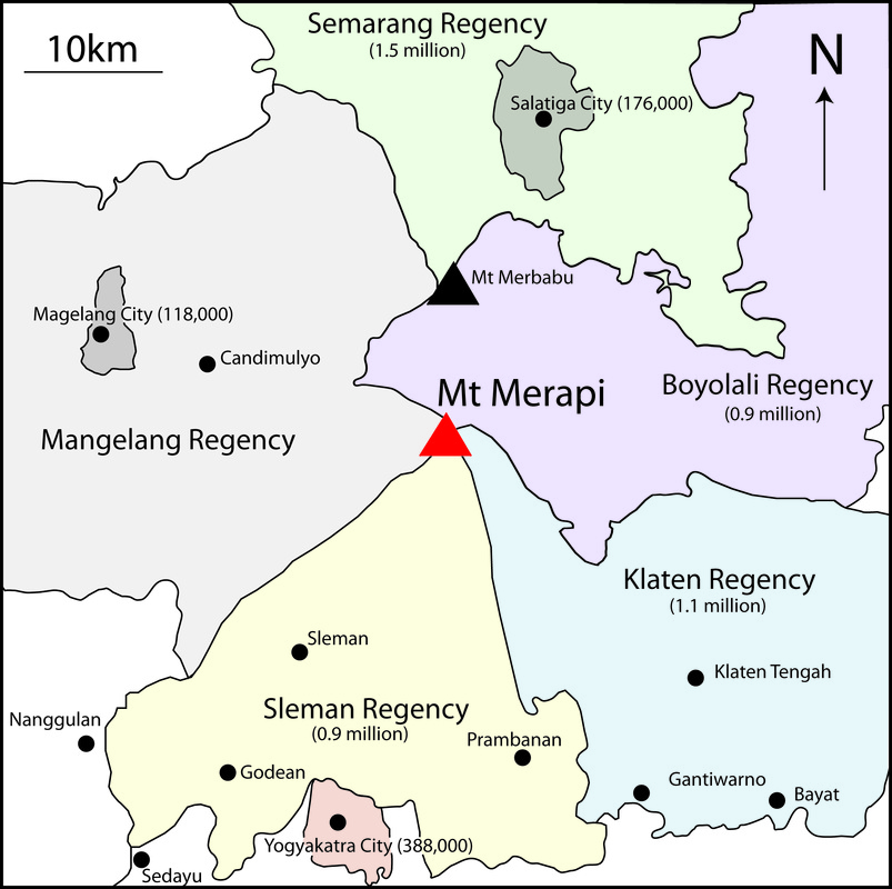
Figure 3: Main regencies and cities surrounding Mt Merapi. Numbers in brackets are estimated populations from wikipedia.org.
Volcanic features
The devastating effects of Merapi's most recent volcanic activity can viewed in Google Earth imagery (Figure 4). White "ribbons" extending outward from the summit represent valley-filling, block-and-ash flows. Less ostentatious volcanic features, however, require more detailed geological mapping (Figure 5)
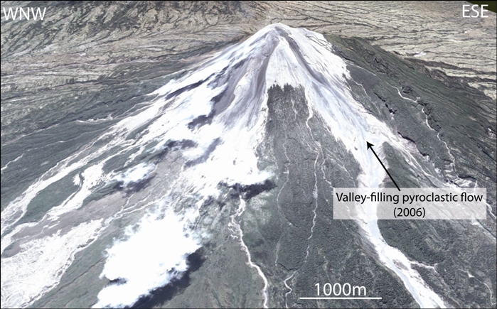
Figure 4: Annotated Google Earth image of Mt Merapi viewed from the SSW.
Geologic Map
The geologic map from Gertisser et al. (2012) below better illustrates the extent of Merapi's volcanic deposits. The youngest deposits are primarily pyroclastic flow, lahar, and avalanche deposits. Recently erupted lavas extend no further than 5km from the summit. Volcanic products of Young Merapi are largely confined to the SW quadrant of the volcano (explained further in the next section).
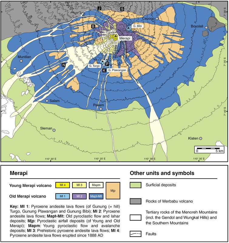
Figure 5: Geology map of Merapi volcano from Gertisser et al. (2012).
