Volcanic Deposits
Lavas
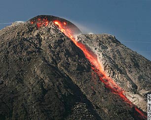
Effusive volcanism at Merapi is primarily confined to the lava dome,which has a long-term effusion rate of 0.039 m3/s (Hammer et al., 2000). Basaltic andesite lavas on Merapi contain 30-51 vol% phenocrysts, and total crystalline contents (phenocrysts and microphenocrysts) are occasionally in excess of 70 vol% (Hammer et al., 2000). Lava flows of New Merapi are confined to areas 5km from the summit and in the last 150 years have not extended past 2km (Figure 5).
Figure 13: Image of lava extruding from the lava dome down the slopes of Mt Merapi (image reference 9).
Figure 13: Image of lava extruding from the lava dome down the slopes of Mt Merapi (image reference 9).
Fall out deposits
Pyroclastic fall deposits from Mt Merapi are moderately wide-spread, and the farthest traveled 5cm isopach occurs ~26km from source (Gertisser et al., 2012). Fine-grained, thin ash deposits were, however, documented up to 400km NE of Merapi during the 1872 eruption Hartmann (1935). Fall deposits in the last 3000 years exhibit variable components from fine ash to fine blocks and bombs of scoria, pumice, and lithics (Andreastuti et al. 2000). Individual eruptive deposits are episodic in nature, exhibiting distinct breaks, which Andreastuti et al. (2000) attribute to Vulcanian-style blockage of the volcanic conduit; this is further evidenced by increases in lithic contents. Ash fall layers are complexly intermingled with flow and surge deposits, showing evidence for plume instability and/or lava dome collapse during these eruptive events.
In contrast to the dominant wind directions (NW and SE) and distribution of ash during smaller, historic eruptions (Thouret et al. 2000), ispoach maps of VEI 3-4 eruptions reveal a dominant westerly wind direction (Figure 14). Additionally, the 1872 VEI 4 eruption exhibited a dominant N to NE distribution of ash (Thouret et al. 2000). There is little mention of this wind discrepancy in the literature, however, I interpret that it is the result of different stratospheric and tropospheric wind directions. In this instance, ash fall from larger eruptions, which have greater columns heights that extend into the stratosphere (e.g. >14km), is carried in a different direction to smaller eruptions with lower eruption columns (e.g. <14km). Consequently, ash from VEI 4 and larger VEI 3 eruptions travels in a direction ranging from WSW to NE.
In contrast to the dominant wind directions (NW and SE) and distribution of ash during smaller, historic eruptions (Thouret et al. 2000), ispoach maps of VEI 3-4 eruptions reveal a dominant westerly wind direction (Figure 14). Additionally, the 1872 VEI 4 eruption exhibited a dominant N to NE distribution of ash (Thouret et al. 2000). There is little mention of this wind discrepancy in the literature, however, I interpret that it is the result of different stratospheric and tropospheric wind directions. In this instance, ash fall from larger eruptions, which have greater columns heights that extend into the stratosphere (e.g. >14km), is carried in a different direction to smaller eruptions with lower eruption columns (e.g. <14km). Consequently, ash from VEI 4 and larger VEI 3 eruptions travels in a direction ranging from WSW to NE.
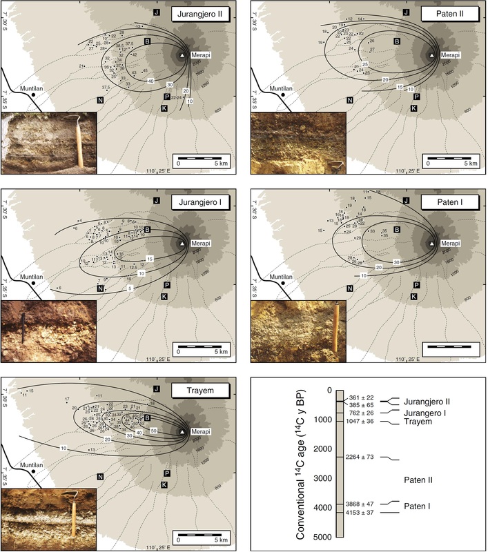
Figure 14: Isopach maps with accompanying deposit photos of five VEI 3-4 eruptions at Merapi from Gertisser et al. (2012).
Pyroclastic flow deposits
The lava dome at the summit of Mount Merapi has been in a state of near-continuous growth and intermittent collapse in the past few centuries (Voight et al. 2000). Gertisser et al. (2012) recognize four main deposits that occur from ground-hugging density currents that are outlined below (Figure 15). The four deposits reveal a spectrum of eruptive styles occurring at Merapi, from Peleeán
to Plinian. Each deposit can be distinguished based on the characteristics of the juvenile components. In historical times, pyroclastic flows have been confined to the SW quadrant of the volcano, where they are directed down 13 major rivers (refer to lahar map in Figure 21). These flows travel up to 15km from source, but have the potential to travel as far as 20km (Thouret et al., 2000). Pyroclastic flows could also travel over the avalanche caldera rim and flow into areas north and east of the volcano every 150-500 years, during VEI 4 eruptions (Thouret et al. 2000).
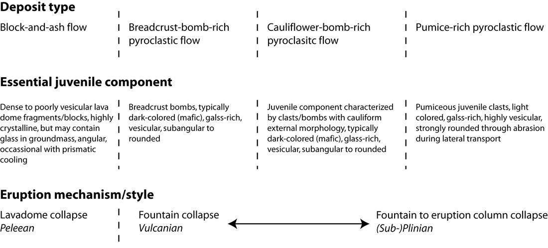
Figure 15: Method for characterizing different pyroclastic flow deposits at Mt Merapi based on the juvenile component of the deposit. Modified from Gertisser et al. (2012).
Block-and-ash flow deposits
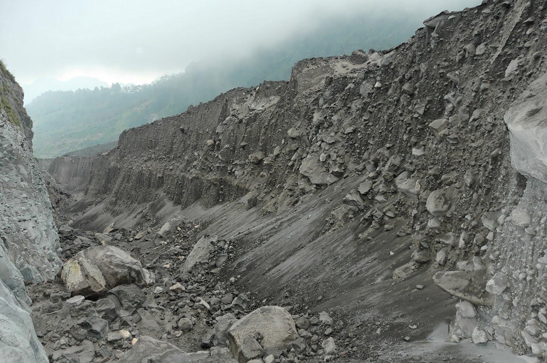
Produced from "Merapi-type" nuées ardentes resulting from Peleeán-style, dome collapse events. These flows are identified from the presence of densely to poorly vesiculated dome fragments.
Figure 16: Image of a block-and-ash flow on Merapi volcano (image reference 10).
Figure 16: Image of a block-and-ash flow on Merapi volcano (image reference 10).
Breadcrust-bomb-rich pyroclastic flow deposits
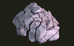
Typically an indicator of fountain collapse during Vulcanian style eruptive activity. Characterized by the presence of dark colored, breadcrust bombs.
Figure 17: Image of the outer crust of a typical breadcrust bomb (image reference 11).
Figure 17: Image of the outer crust of a typical breadcrust bomb (image reference 11).
Cauliflower-bomb-rich pyroclastic flow deposits
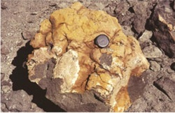
Associated with fountain collapse during Vulcanian to Sub-Plinian eruptions. Identified from the presence of bombs with an external cauliform morphology (i.e. an irregularly lumpy exterior).
Figure 17: Cauliflower bomb from Merapi volcano. Photo from Gertisser et al. (2012).
Figure 17: Cauliflower bomb from Merapi volcano. Photo from Gertisser et al. (2012).
Pumice-rich pyroclastic flow deposit
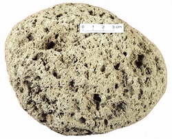
These deposits form from column collapse during (Sub-)Plinian eruptions. The essential juvenile component is pumice.
Figure 18: Photo of pumice (image reference 12).
Figure 18: Photo of pumice (image reference 12).
Lahars
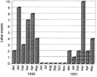
Lahar deposits on Merapi are typically 0.5-2.0m thick, however, when channelized the deposits can reach thicknesses up to 10m (Lavigne et al., 2000). The deposits are poorly sorted with clay to boulder-size particles. The source for lahars are typically coarse-grained block-and-ash flows, and thus the lahars will often have a sandy to gravely texture. Occasionally, lahars can be almost solely composed of fine-grained tephra. Lahars occur on Mt Merapi every 2-4 years, usually during an eruption or in rainy seasons for 1-2 years following an eruption (Fig 19). Lahars documented since the 16th century have flowed down 13 main rivers all located in the SW quadrant. The longest flows extend 25-30 km from source (Lavigne et al. 2000: Figure 21). Lahar footage can be viewed in video 3.
Figure 19: Lahar events during rainy seasons following the 1930 eruption. From Lavigne et al. (2000).
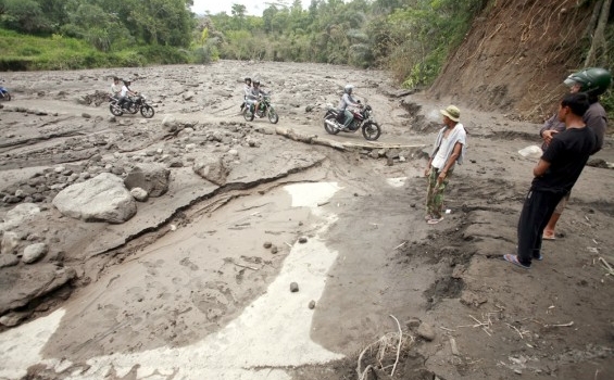
Figure 20: People crossing lahar deposits of Mt Merapi (image reference 13). Note the large, rounded boulders within a fine-grained matrix.
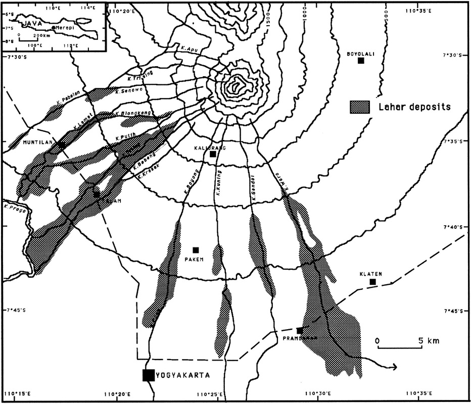
Figure 21: Extent of Mt Merapi lahar deposits since the 16th Century. From Lavigne et al. (2000).
